www.
WhalingCity
.net
New Bedford, Massachusetts
Home Page
Pictures and History
Places and Their History
Theaters and Entertainment
People Pics and Biographies
Whaling Images and History
Mayors List
City Parks
New Bedford Maps
New Bedford Videos
New Bedford Books, Etc.
Festivals and Fairs
Function Halls - Restaurants
Local Links
Things to do
New Bedford City Directories
Chronological History
Local History - 1600's to 1699
Local History 1700 - 1749
Local History 1750 - 1777
Local Revolutionary War 1778
Local History 1779 - 1799
Local History 1800 - 1819
Local History 1820 - 1829
Local History 1830 - 1839
Local History 1840 - 1849
Local History 1850 - 1858
Local History 1859 Fires!
Local History 1860 - 1869
Local History 1870 - 1879
Local History 1880 - 1889
Local History 1890 - 1899
Local History 1900's
Local History 1900 - 1909
Local History 1910 - 1919
Local History 1920 - 1929
Local History 1930 - 1939
Local History 1940 - 1949
Local History 1950 - 1959
Local History 1960 - 1969
Local History 1970 - 1979
Local History 1980 - 1989
Local History 1990 - 1999
Local History 2000 - 2009
Local History 2010
Local History 2011
Contact webmaster
This site - work in progress.
If you have any public domain photographs of historical interest to donate, whether scanned or printed please contact the
webmaster, Roger Chartier
and your submission will be credited if it is displayed on this site.
By
Roger Chartier
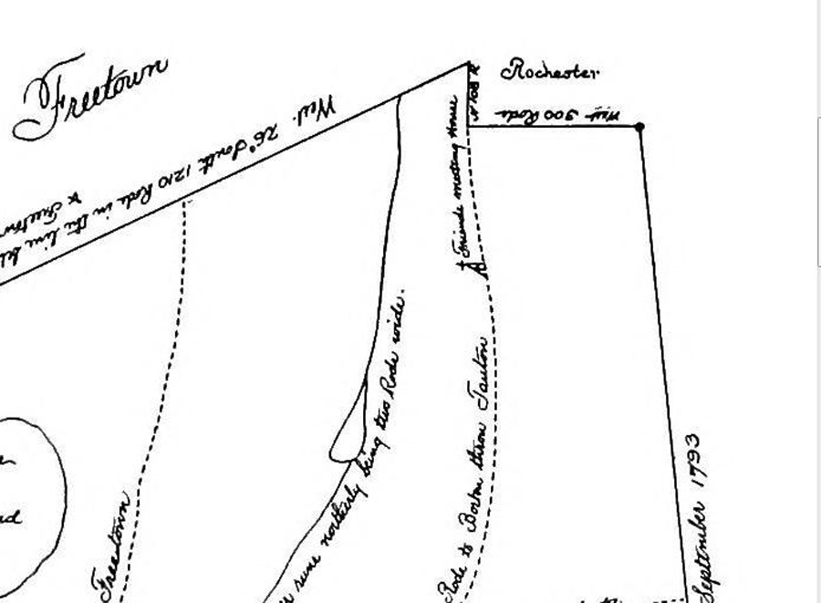
The 1795 map of
New Bedford, Ma. - Top Section
Click on the map to see a large version
Early New Bedford had fewer streets and in
1795
this map was
made of the streets and roads that sometimes were no better than cart paths.
This map shows the sparcely settled area of northern New Bedford and the boundary of neighboring
Freetown, Rochester and Acushnet.
There was a dispute over the dartmouth boundary for a while.
www.sailorsongs.com
www.ourwholeworld.com
www.Taxman123.com
www.RC123.com
www.rogerchartier.com
www.moneytopaythebills.com
www.menujoy.com